1 ñ 2 ñ 3† RULE OF TROPICAL CYCLONE AVOIDANCE
(Content and graph from NOAA, provided here by WeatherCarib.com)
For vessels at sea, avoiding
the 34 KT wind field of a tropical cyclone is paramount.† Any ship in the vicinity of a tropical
cyclone should make every effort to remain clear of the maximum radius of analyzed
or forecast 34 KT winds associated with the tropical cyclone.† Knowing that the area of 34 KT around
tropical cyclones is rarely symmetric but instead varies within semi-circles or
quadrants is important.† Understanding
that each tropical storm or hurricane has it own unique 34 KT wind field are
necessary factors to account for when attempting to remain clear of this
dangerous area around a tropical cyclone.†
NHC forecasts attempt to define the structure of this wind field and use
of the latest TCM in determining the maximum radius of 34 KT winds is necessary
when trying to avoid this dangerous threshold.
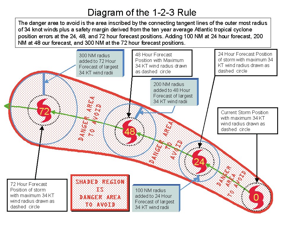
1.†† Plot the current and
forecast tropical cyclone positions taken from the latest TCM.
2.†† Find the maximum radius of
34 KT winds at the current and each forecast time period of the TCM out to 72
hours.
For example, the radii of 34 KT winds given for the 24 hour forecast
position
in
the latest TCM are:
34 KT...175NE 150SE 150SW 150NW
Therefore, the maximum radius of 34 KT winds associated with the
tropical
cyclone
at its 24-hour forecast position is 175 NM.
3.†† Next
apply the 1-2-3 rule to each of the radii at the 24, 48, and 72 hour forecast
positions.
At the 24-hour forecast position (1 day): add 100 NM to the maximum
radius
of
34 KT winds found in the 24 hours forecast of step two.
>>>
175 NM (Forecast radius of 34 KT) + 100 NM = 275 NM
At the 48-hour forecast position (2 days): add 200 NM to the maximum
radius
of
34 KT winds found in the 48 hour forecast of step two.
At the 72-hour forecast position (3 days): add 300 NM to the maximum
radius
of
34 KT winds found in the 72 hour forecast of step two.
4.†† Now draw a circle around
the 24, 48, and 72 hour forecast positions of the tropical cyclone using the
radii found in step 3.
5.†† Connect a
line tangent to each circle constructed in step 4.† The area enclosed by these tangent lines is known as the danger
area of the tropical cyclone and must be avoided as a vessel attempts to
navigate in the vicinity of the tropical cyclone.
Note of caution. This rule establishes a
minimum recommended distance to maintain from a tropical cyclone in the
Atlantic Basin.† Larger buffer zones can
and should be established in situations of tropical cyclones with large forecast
uncertainty, limited crew experience, decreased vessel handling, or other
factors as determined by the vessel master.†
The 1-2-3 rule does not account for sudden & rapid intensification
of tropical cyclones that could result in a rapid outward expansion of the 34
KT wind field.† Also, the 1-2-3 rule
does not account for the typical outward expansion of the wind field as a
system transitions from tropical cyclone to extratropical gale or storm in the
North Atlantic.† Finally, mariners
should not equate the radius of 34 KT winds with the area of 12-foot seas in
the vicinity of a tropical cyclone.† The
1-2-3 rule relies solely on avoiding the radius of 34 KT winds in a tropical
cyclone and does not take sea heights into consideration. Vessels with lower
sea keeping limits should also make adjustments to the 1-2-3 rule in order to
minimize exposure to seas that will dangerously hamper ship stability and
maneuverability.† The radius of current
12-foot seas is issued in the TCM and can serve as a gauge for vessels with
lower sea keeping limits in order to remain clear of potentially damaging
higher seas.† Further guidance on
forecasted seas in excess of 12 feet in the vicinity of any active tropical
cyclone is available in the Atlantic High Seas Forecasts issued by TPC and MPC.